
Waimea Canyon Topo Map
by Marcia Minnichhofer on 09/22/17
Note: Those who have visited the Canyon know that in reality, you cannot walk down to the bottom of the Canyon from this viewing area.
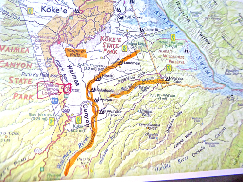
Also, I looked at topo maps trying to determine where the water in the streams was coming from. (No conclusion.) The Alakai Swamp feeds the Waimea River. And the water in the Alakai Swamp is mostly coming from Mt. Waialeale, the "wettest spot on the earth." (There is a long, moderate but worthwhile hike to the Swamp.) During summer, the streams at the Canyon Lookout are less visible than after heavy rain. The waterfall in my painting is called Waipo'o Falls (at the left on this map) and it is fed with water from the Kokee Stream. The Waimea River is highlighted in orange and is flowing south to the town of Waimea. The Canyon lookout is circled in red. You are facing northeast when viewing the Canyon from the lookout.

Comments (0)